
The 2026 Atlantic Hurricane Season Begins: What Are Experts Expecting?
The 2026 Hurricane Season in the Atlantic officially began today on June 1. You may have already heard a lot of buzz about the seasonal forecast for this year, especially relating to how a strong El Niño may play a role later in the summer. We’re here to break the science down bit by bit in this blog post.
Firstly, agencies such as the National Oceanic and Atmospheric Administration (NOAA) and Colorado State University have released their forecasts for the Atlantic Hurricane Season [1, 2]. Both agencies call for a slightly below average Atlantic tropical cyclone activity overall in 2026, citing cooler sea surface temperatures in the tropical Atlantic compared to the last several years [1, 2]. The Main Development Region (MDR) in the tropical North Atlantic (see Figure 1) is where most tropical cyclones form from incipient disturbances coming off the coast of Africa [3]. The more important factor this year, however, that both agencies cited for the below-normal forecast is, ironically, a phenomenon that takes place thousands of miles away from the MDR. This phenomenon, El Niño, has implications for weather and climate across the globe [4]. For the Atlantic, it generally results in higher-than-normal wind shear being projected across the basin (Figure 2), which is hostile to developing tropical storms and hurricanes (we have previously published a blog post discussing the detailed impacts of El Niño on Atlantic hurricanes. You can check that out here: https://www.kinanco.com/blog/2023/6/27/unusual-june-in-the-tropical-atlantic-what-could-it-mean-for-the-2023-hurricane-season) [4].
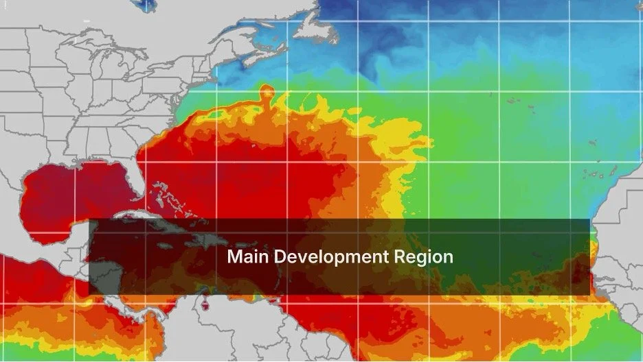
Figure 1: Main Development Region. Warmer colors represent higher sea surface temperatures, conducive to tropical cyclone formation. Source: https://weather.com/science/weather-explainers/news/2025-08-12-weather-words-main-development-region-2025
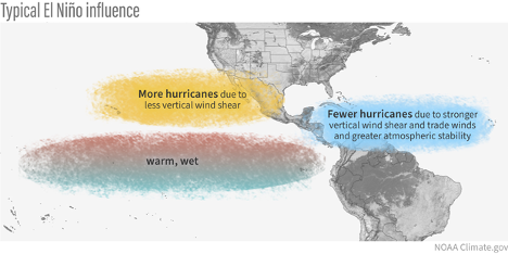
Figure 2: Typical El Niño influence on Atlantic and Eastern Pacific basin tropical cyclone activity. Source: https://www.climate.gov/news-features/blogs/enso/impacts-el-nino-and-la-nina-hurricane-season
Given that seasonal hurricane forecasts are not infallible, it’s natural to ask about the uncertainty in this year’s forecast and what this means for any given location regarding potential impacts this hurricane season. Overall, experts are quite confident this year that a strong El Niño will form (backed by model consensus indicating that it could be potentially one of the strongest in the historical record) [5, 6]. And the correlation between El Niño conditions in the Pacific and reduced overall tropical cyclone activity in the Atlantic is statistically meaningful [7], though it does not capture the full picture. For example, 2023 featured another strong El Niño in the Pacific, yet the hurricane season in the Atlantic that year was one of the most active on record [8]. However, 2023 also featured one of the strongest basin-wide marine heatwaves in the Atlantic on record, with temperature anomalies as high as 1-2 degrees Celsius in spots [9]. What this effectively meant was that, in 2023, the Atlantic Ocean was so warm that, through enhanced convection, it was able to counteract some of the suppressive effects of the El Niño in the Pacific [8, 9].
Looking at this year’s forecasts of tropical cyclone activity in Atlantic this year, however, one sees a different story (see Figure 3). While sea surface temperatures are generally above average in the Gulf of Mexico and in the western Atlantic east of Florida, the region where most tropical cyclones bud and develop is 1-2 degrees Celsius cooler than normal. Thus, the Atlantic does not have the strong “defense mechanism” in place this year that it did back in 2023. Furthermore, when tropical cyclone-suppressive conditions align, such as the development of El Niño coupled with the cool SSTs in the tropical Atlantic, confidence tends to generally go up with regards to a below-average hurricane season throughout the basin.
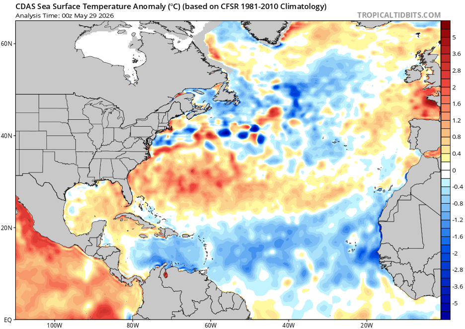
Figure 3: Sea surface temperature anomaly (deg C) for May 29, 2026 from CDAS, based on CFSR 1981-2010 climatology. Source: https://www.tropicaltidbits.com/analysis/ocean/
But herein lies another issue: overall basin activity does not equate to impacts. An example that scientists frequently cite is the 1992 hurricane season in the Atlantic [10]. Despite featuring well below-average activity (only 7 named storms), it was also the year that featured Category 5 Hurricane Andrew, the storm that ripped through south Florida and forever impacted the way we understand tropical cyclones (not just from a forecasting perspective, but also an impacts and insurance point of view) [11, 12]. It is for this reason that scientists and experts consistently emphasize the importance of being prepared regardless of what the seasonal forecasts state. This means having your hurricane plan in place, knowing when/where you will evacuate to, and having a basic hurricane safety kit so that you have adequate supplies to last you through the storm.
Here at Kinetic Analysis Corporation, we pride ourselves in being a leader in the hurricane risk modeling industry. Every year, we aid clients from insurance to emergency managers and government agencies in preparing for the impending impacts from tropical cyclones on a global scale. Through this mission, we understand the pain points of our clients and can help identify weaknesses in your current hurricane preparedness architecture. For more information, feel free to check out our website (https://www.kinanco.com). To schedule a free consultation with us, please email us at sales@kinanco.com.
References
1. https://tropical.colostate.edu/forecasting.html
4. https://www.pmel.noaa.gov/elnino/impacts-of-el-nino
5. https://iri.columbia.edu/our-expertise/climate/forecasts/enso/current/
6. https://www.metoffice.gov.uk/blog/2026/met-office-what-is-el-nino-and-will-we-see-one-this-year
8. https://journals.ametsoc.org/view/journals/bams/105/9/BAMS-D-23-0305.1.xml
9. https://www.nature.com/articles/s41586-025-08903-5
10. https://www.nhc.noaa.gov/data/mwreview/1992.pdf
11. https://www.iii.org/sites/default/files/paper_HurricaneAndrew_final.pdf
12. https://science.nasa.gov/earth/earth-observatory/remembering-hurricane-andrew-78948/