
Could a “Super El Niño” be Coming This Summer?
You may have heard a lot of buzz lately about a “Super El Niño” expected to develop by summer/fall of this year. But what is a Super El Niño and are we heading toward one?
The term “Super El Niño” is a colloquial term, as there is no official scientific classification for this phenomenon. However, climate models do suggest a transition to an El Niño conditions by summer of 2026, and many are suggesting that it could get quite strong [1]. El Niño is the warm phase of the El Niño Southern Oscillation (ENSO), which is a recurring climate pattern involving changes in the sea surface temperature of the equatorial central and eastern Pacific Ocean [2]. El Niño occurs when the central and eastern tropical Pacific surface water temperatures (SSTs) are warmer-than-normal by at least 0.5°C on average [2, 3]. The area of the equatorial Pacific most used to diagnose El Niño is the Niño 3.4 region, shown in Figure 1 [2, 3]. The warming in this region causes large downstream climate impacts around the globe [2]. Some areas, such as southeast Asia and Australia, tend to see prolonged drought during El Niño events while other locations, such as the southern United States, experience enhanced rainfall and increased flood risk [4].
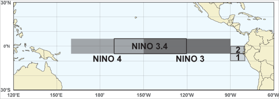
Figure 1: Niño regions with Niño 3.4 boxed. Source: https://psl.noaa.gov/data/timeseries/month/Nino34/
The warmer SSTs in the central and eastern Pacific enhance the number of thunderstorms and convection in the region [5]. In turn, the upward motion of air in these convective systems becomes horizontal when reaching the top of the troposphere (the part of the atmosphere where weather occurs) and generates strong upper-level winds that flow into the Atlantic basin, often disrupting the development of Atlantic tropical cyclones [5]. In other words, through its enhancement on thunderstorm activity/convection in the tropical Pacific, El Niño tends to increase overall wind shear in the Atlantic. Increased wind shear is a prohibitive factor for budding tropical systems, and strong El Niño events in the Pacific tend to be correlated with below average tropical activity in the Atlantic in any given year [5].
So how likely is it that El Niño forms this summer, and just how strong are we expecting it to get? Figure 2 shows the forecast probabilities from the National Oceanic and Atmospheric Administration Climate Prediction Center. Current forecasts place the probability of El Niño conditions at over 90% by late this summer/early fall. In addition, Figure 3 shows the forecast ENSO state from various dynamical and statistical weather models. Keep in mind that NOAA declares an El Niño event when the 3-month average SST in the Niño 3.4 region is 0.5°C or more above average, and the atmosphere has responded with weakened trade winds [1, 2, 3, 6]. A Weak El Niño has average SST anomalies in the Niño 3.4 region of 0.5 to 1°C, a Moderate El Niño 1 to 1.5°C, a Strong El Niño 1.5 to 2°C, and a Very Strong El Niño >2°C [6]. Only three instances in the historical record since 1950 have been Very Strong El Niño events: 1982-83, 1997-98, and 2015-16 [6]. Nonetheless, we can see from Figure 3 that many models are expecting a transition to at least a moderate El Niño by the summer, with some members showing anomalies as high as 2.0 to 2.5°C above normal in the ENSO 3.4 region [1].
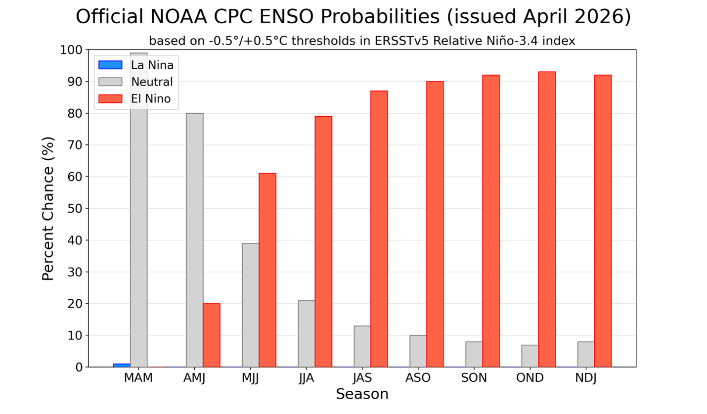
Figure 2: Probability of La Niña (cold ENSO phase), El Niño (warm ENSO phase), and neutral ENSO conditions for 3-month periods starting in March, April, May (MAM). Source: https://iri.columbia.edu/our-expertise/climate/forecasts/enso/current/
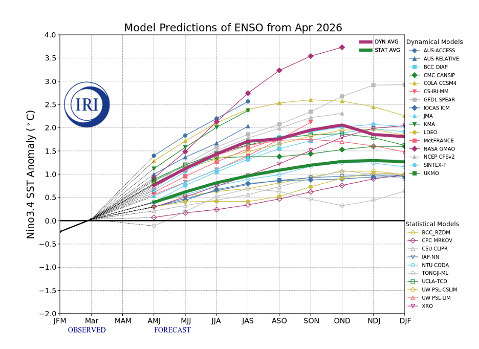
Figure 3: Predictions of mean ENSO conditions from various dynamical and statistical weather models. Source: https://iri.columbia.edu/our-expertise/climate/forecasts/enso/current/
Besides its impact on teleconnections and tropical cyclone activity in the Pacific and Atlantic basins, El Niño events result in large amounts of heat typically sequestered in the oceans being released into the atmosphere. Consequently, many of the warmest years in the historical record have occurred during El Niño events, and 2026 is expected to be no different [7]. If a “Super” El Niño does form later this summer/fall, it is quite possible that 2026 and/or 2027 will be the warmest years on record for our planet, with the average anomaly potentially exceeding 1.5°C when compared to pre-industrial levels [7].
References
1. https://iri.columbia.edu/our-expertise/climate/forecasts/enso/current/
3. https://www.weather.gov/fwd/indices