
Update on the Strengthening El Niño in 2026
A few months ago, Kinetic Analysis Corporation published a blog post on the developing El Niño in 2026 and its impacts on the hurricane season. In this blog post, I wanted to discuss the current strength of the El Niño event and the forecasts going into the fall and winter months.
As of early July 2026, a strong El Niño event is currently underway, as mean sea surface temperatures (SSTs) have already reached +1.7°C above average in the Niño 3.4 region [1]. However, the National Oceanic and Atmospheric Administration notes that SSTs could still rise further with persistent westerly winds resulting in a rapidly strengthening event [1, 2]. Analyses of ocean data show that there is even more warm water to come on top of what is already present.
The official outlook predicts a 63% chance of sea surface temperatures (using the Relative Oceanic Niño Index) exceeding the 2°C threshold from late 2026 into early 2027, officially placing this in the "very strong" El Niño category (see Figure 1) [1, 2].
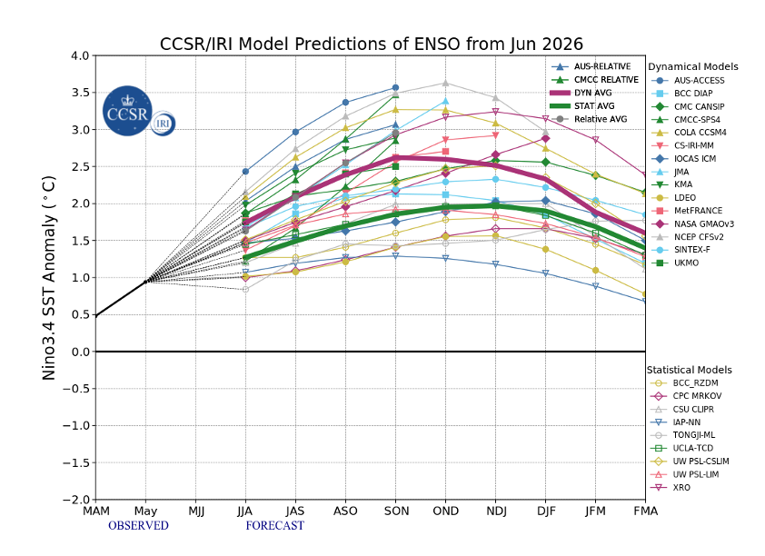
Figure 1: Predictions of mean ENSO conditions from various dynamical and statistical weather models. Source: https://iri.columbia.edu/our-expertise/climate/forecasts/enso/current/
Certain models are even more aggressive. For example, the latest forecast model guidance from the Climate Forecast System version 2 (CFSv2) was literally off the charts (see Figure 2). The maximum value on the y-axis previously only went to 4 degrees Celsius; this prompted NOAA to extend their axes after some of the model guidance were predicting anomalies approaching nearly 5 degrees Celsius.
Now while I think that +5 degrees Celsius anomalies in the Nino3.4 region are quite farfetched, the fact that any sort of dynamical climate model is predicting this magnitude of warming speaks to the significance of the El Niño event forecast for the end of this year. In the next section of this post, however, I want to discuss some of the global weather and climate impacts that this El Niño could have.
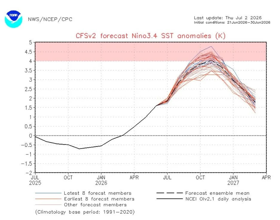
Figure 2: Climate Forecast System version 2 forecast for Nino3.4 sea surface temperature anomalies initialized for the period 21 June 2026 – 30 June 2026. Source: https://www.cpc.ncep.noaa.gov/products/CFSv2/CFSv2seasonal.shtml
The first and most obvious climate impact is the rise in global temperatures in 2026-2027. Because El Niño releases massive amounts of heat from the Pacific Ocean into the atmosphere, the World Meteorological Organization expects global temperatures to reach new record levels [2]. The warmer ocean waters also threaten marine life, devastating ecosystems like coral reefs through severe bleaching [2, 3]. In the eastern Pacific, the disruption of cold, nutrient-rich waters starves small fish and harms upwelling-dependent fisheries [3].
The risk of droughts and wildfires also becomes amplified during strong El Niño years, particularly in parts of Asia and Australia (see Figure 3). Altered rainfall and drought stress major agricultural regions, threatening staple crops like rice and exacerbating global food insecurity [2, 3]. On the other hand, the southern United States, northern Mexico, and regions along the western coast of South America (including Peru and Ecuador) face increased risks of above-average rainfall and dangerous flooding. Areas of equatorial and East Africa are also likely to experience wetter-than-normal conditions [3].
Then there’s the impact on tropical cyclones, which we’ve discussed in previous blog posts. To summarize, warmer ocean temperatures fuel more intense tropical cyclones and typhoons in the Pacific [4]. Conversely, El Niño typically suppresses hurricane formation and activity in the Atlantic due to increased wind shear.
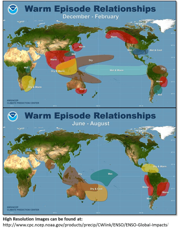
Figure 3: El Niño impacts on global weather and climate. Top panel is December-February, bottom panel is June-August. Figure borrowed from: https://earth.org/el-nino-southern-oscillation/
However, perhaps the most significant impact to the global climate system is the cascading effect that El Niño can have on global warming. It is important to note that El Niño itself does not change the long-term trajectory of human-caused climate change. Instead, it acts as a short-term accelerator. Human emissions have raised the global baseline temperature; when a strong El Niño arrives on top of that baseline, it pushes the climate system into unprecedented extremes, setting off these feedback loops with much greater intensity than in the pre-industrial past [5, 6, 7, 8].
One of these feedback loops results from temporary reduced land carbon sinks; El Niño brings extreme droughts to massive tropical carbon sinks like the Amazon basin, Southeast Asia, and parts of Africa. Under severe water stress, vegetation slows down photosynthesis, meaning forests temporarily absorb significantly less carbon dioxide from the atmosphere [9, 10, 11]. The intense heat and lack of rainfall can also turn forests and peat bogs—particularly in Indonesia and Australia—into tinderboxes. The resulting large-scale wildfires can release billions of tons of stored carbon directly into the atmosphere, creating a direct feedback loop [9, 12, 13].
Since El Niño begins in the ocean, the oceans play a large part in this feedback loop as well. Under normal conditions, strong westward trade winds off the coast of South America cause upwelling which pulls up cold, nutrient-rich, and carbon-absorbing deeper waters. During an El Niño, these winds weaken or reverse. The ocean surface warms, stratification increases, and the ocean's natural capacity to absorb atmospheric carbon is temporarily reduced [14, 15]. Warm ocean anomalies can also dissipate the expansive decks of low marine stratocumulus clouds that normally sit off the western coasts of North and South America. Without these white clouds to reflect sunlight back into space, the darker ocean absorbs more solar radiation, warming the regional sea surface even further [16].
Regardless of how El Niño may impact a specific location, one thing is clear: this El Niño event is likely to go down in history as one of the strongest, if not the strongest, in recorded history. It will have profound global implications on weather and climate and could result in 2026-2027 being the warmest period that the Earth has seen since the Industrial Era.
References
1. https://iri.columbia.edu/our-expertise/climate/forecasts/enso/current/
2. https://news.un.org/en/story/2026/07/1167870
3. https://earth.org/el-nino-southern-oscillation/
4. https://www.aoml.noaa.gov/how-does-el-nino-impact-atlantic-hurricane-season/
5. https://www.science.org/doi/10.1126/science.aam5776
6. https://www.lesaffre.com/trends-mag/interactions-between-microorganisms-and-climate-change/
7. https://www.sciencedirect.com/science/article/pii/S0048969726004419?via%3Dihub
8. https://www.nature.com/articles/s41586-025-09085-w
9. https://www.mpic.de/4466519/knapp-neun-milliarden-tonnen-mehr-co2
10. https://www.imperial.ac.uk/grantham/publications/climate-change-faqs/what-is-el-nino/
12. https://www.wri.org/insights/climate-fire-feedback-loop-explained
13. https://www.sciencedirect.com/science/article/pii/S1674283425000091
14. https://www.science.org/doi/10.1126/science.aam5776
15. https://iri.columbia.edu/our-expertise/climate/enso/why-do-we-care-about-el-nino-and-la-nina/
16. https://archive.ipcc.ch/ipccreports/tar/wg1/303.htm