
The Three Pillars of Risk Modeling: Hazard, Exposure, and Vulnerability
Part 1: Hazard
Often when discussing the risks associated with natural disasters, the terms “risk” and “risk modeling” get thrown around. But how exactly does the industry define risk with regards to a natural event like a tropical cyclone/hurricane? And how does this definition of risk play into our current approach of simulating these phenomena in contemporary risk modeling frameworks?
In the context of a natural event such as a hurricane, risk can be understood as consisting of three main pillars. These are the hazard, exposure, and vulnerability [1]. The hazard refers to purely natural phenomena, such as the winds, waves, rainfall, and storm surge associated with a tropical cyclone (see Figure 1) [1, 4]. Exposure refers to the manmade structures and people that will be affected by the hazard and includes information such as population and gross domestic product (GDP) on a national level all the way down to detailed, site-specific information about the contents of a structure [1]. Lastly, vulnerability describes the damage or loss to a given exposure (such as a commercial, public, or private structure) caused by a hazard with a specific intensity (for example, a certain wind speed) [1]. All three of these ideas make up what is known as the “Crichton risk triangle” in risk modeling (Figure 2) [2].
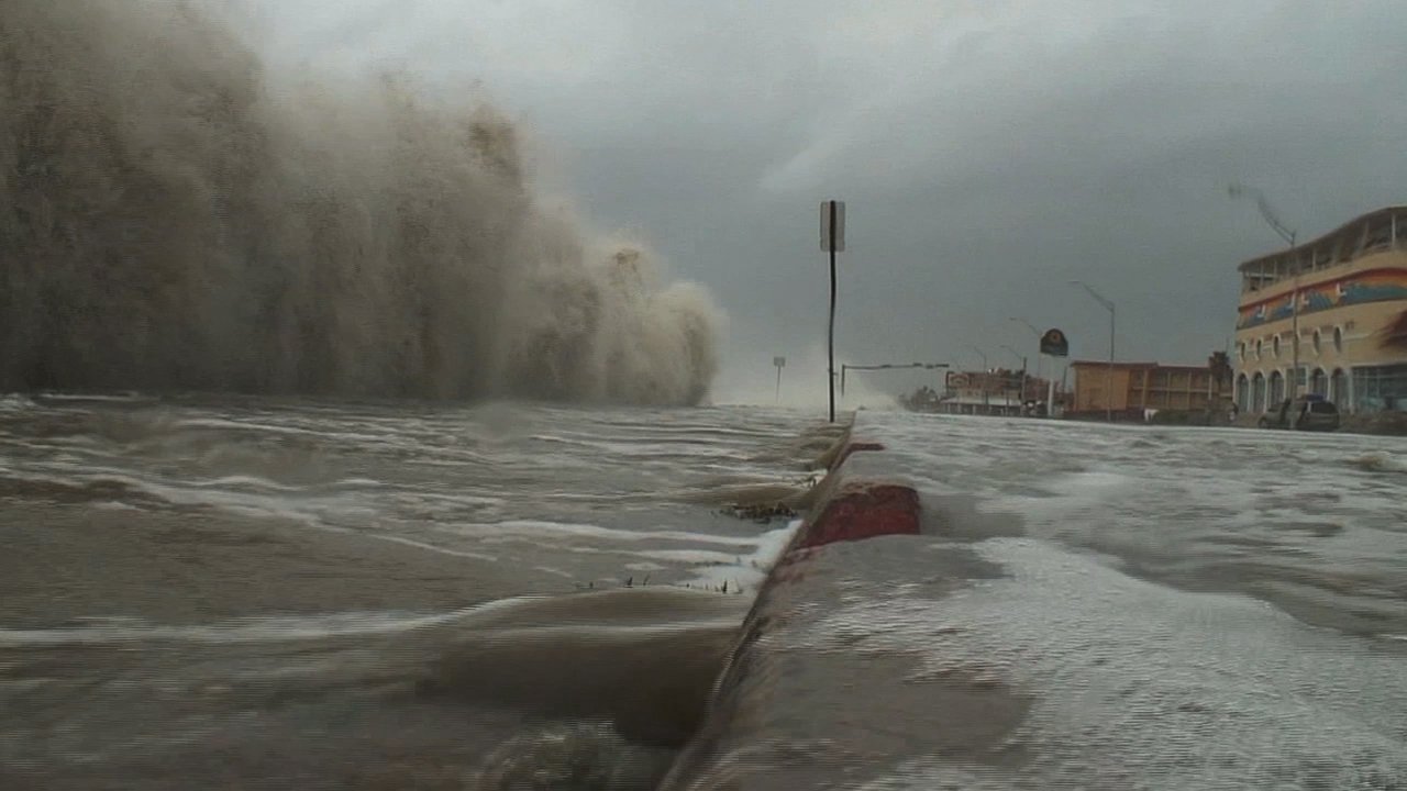
Figure 1: Storm surge is water from the ocean that is pushed ashore by the force of the wind from a hurricane. Storm surge is the most deadly hazard from a tropical cyclone. Image borrowed from: https://oceantoday.noaa.gov/hurricanestormsurge/
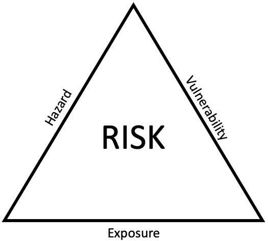
Figure 2: Crichton risk triangle (coined by David Chrichton) associated with a natural disaster [2]. Risk can be defined as a composite of the hazard, exposure, and vulnerability associated with an event. If any of the three factors is magnified, then the total risk increases, sometimes nonlinearly.
Now that the three pillars of risk have been defined, it’s important to elaborate on each and understand how these concepts are incorporated in risk models. In this blog post, we will focus on the hazard framework. In part 2 and 3, we will dive deeper into exposure and vulnerability, respectively. For hazards, the first step in risk assessment needs to be the calculation of the probability, intensity, and geographic distribution of the hazard [1]. This requires data on the geological, meteorological, and hydrological processes that cause the hazard (for example, storm tracks for tropical cyclones or fault lines for earthquakes) [1]. Historical events often form an important component of this data, as prior information on the date, location, extent, and maximum intensity of tropical cyclones can provide a useful tool to develop and validate the modeled hazard [1]. Historical events can also be used to assess changes in risk over time due to growing exposure (i.e., if X event in 1950 were to happen today, what would the resulting economic loss be?) [1]. Lastly, we can use historical events to compute return periods, which give us an idea of the probability/frequency of a particular location experiencing a given level of hazard (Figure 3) [3].
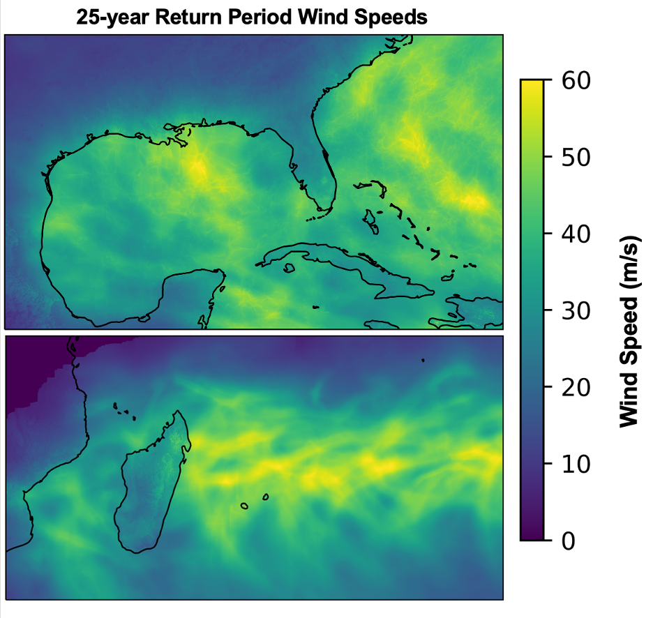
Figure 3: 25-year return period map of wind speeds from tropical cyclones in two regions: (top) the Gulf of Mexico and western Atlantic and (bottom) the southwest Indian Ocean and southeastern coastline of Africa. The 25-year return period wind speeds shown in the top figure are based on the National Hurricane Center's best-track data for tropical cyclones that occurred from 1950 through 2021. The winds shown in the bottom figure are based on the Joint Typhoon Warning Center's best-track data for tropical cyclones that occurred from 1980 through 2021. The winds represent terrain-adjusted, 1-minute sustained winds at 10-meter elevation. Note that winds equal to or faster than the return period winds can occur more than once in a year, or in consecutive years.
Historical data is typically insufficient to precisely model probability of experiencing hazards from an infrequently occurring event such as an earthquake or tropical cyclone. One approach used to better characterize the probability of a location experiencing a hazard from an extreme event is to create a catalog of synthetic events using information gleaned from the historical record. Such catalogs contain synthetic events that could occur over an extended period, for example, thousands or hundreds of thousands of years. Statistics that characterize the catalog of events, for example, the average event frequency and the distribution of event intensity, and location of events, should be consistent with the historical record.
The basic hazard data need to be supplemented with additional information. For example, to calculate surface winds from a tropical cyclone, one needs an accurate and detailed picture of surface roughness and topography to calculate storm wind speeds at ground level. Or, to calculate flood depth from rainfall, one needs estimates of soil moisture to account for the ability of soils to absorb precipitation instead of having surface runoff. [1]. To verify modeled results of an actual results, an observing network is desirable, though sometimes not possible depending on the part of the world where the hazard is being modeled [1]. Observations of phenomena such as surface pressure measurements, wind speed, and radius of maximum winds, can be used with empirical relationships to fill in observational gaps and provide a more complete picture of the spatial distribution of hazards from an event [1].
The first pillar in defining risk, hazard, is the most physical component (i.e., it is the component that humans have the least influence over). The other two components, exposure and vulnerability, have much greater human influences. In our next blog post, we plan to expand upon these two factors in order to develop a more complete understanding of risk.
References
1. http://dx.doi.org/10.1108/IJDRBE-06-2015-0033
2. https://www.ilankelman.org/crichton/1999risktriangle.pdf
3. https://www.gfdrr.org/en/100-year-flood#:~:text=Return%20periods%20are%20a%20common,frame%20defined%20by%20a%20probability.
4. https://oceantoday.noaa.gov/hurricanestormsurge/