
The Major Takeaways of the 2023 Hurricane Season
Welcome to part 3 of Kinetic Analysis Corporation’s analysis of the 2023 hurricane season in the Atlantic and Northeast Pacific. Part 1 focused primarily on the Atlantic and its impacts. Part 2 looked at the Eastern Pacific and the numerous storms that impacted mainland Mexico. In this post, we plan to look at commonalities between the two basins and what those similarities reveal about broader climate trends in the 21st century.
The most striking similarity that we discuss in our previous posts is that both the Atlantic and the Eastern Pacific were anomalously warm throughout much of the summer and fall of 2023 [1, 2]. The Atlantic was at record warm levels for a long stretch of the season, and the Eastern Pacific maintained average SST anomalies greater than 1°C throughout the season. [1, 2, 4]. In response to the warm surface waters, both regions experienced above normal activity in the number of named storms and hurricanes as well as in the total energy, as quantified by the Accumulated Cyclone Energy (ACE), released by storms throughout the seasons [1, 2, 4].
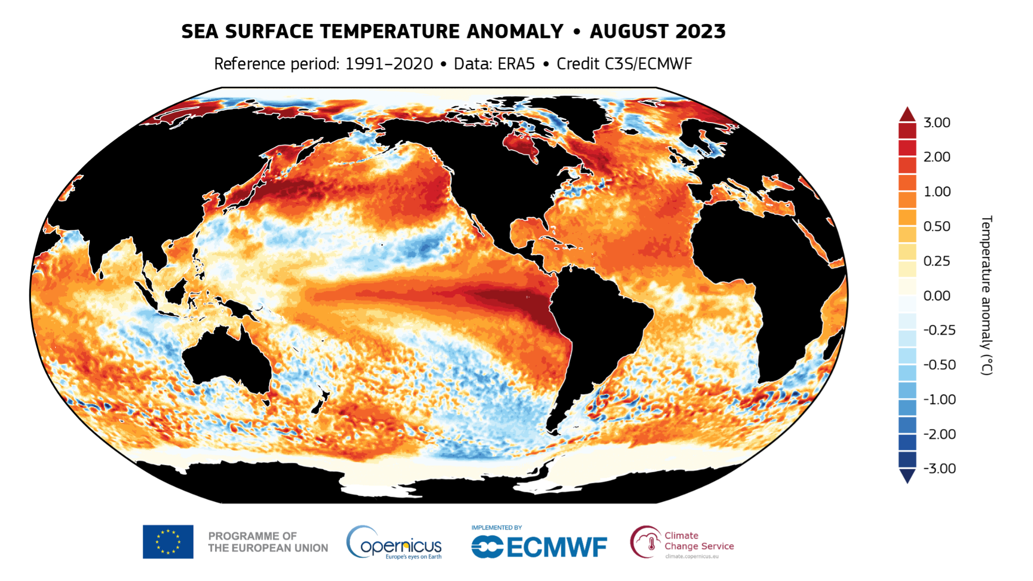
Figure 1: Sea surface temperature anomaly (°C) for August 2023, relative to the 1991-2020 reference period. Data source: ERA5. Credit: Copernicus Climate Change Service/ECMWF.
Aside from this obvious commonality, one key theme of the 2023 hurricane season was rapid (and explosive) intensification. Rapid intensification (RI) is defined as a process in which a tropical cyclone’s maximum sustained winds increase by 35 miles per hour (or more) within a period of 24 hours [3]. As Idalia churned through the Gulf of Mexico before approaching Florida’s Big Bend area, its winds increased from 75 miles per hour to 130 miles per hour in just 24 hours [3]. This dramatically increased the storm’s potential to harm property and lives [3]. Fortunately, the storm made landfall at low tide in a sparsely populated region of the Big Bend, meaning the impacts were tempered somewhat [3].
Idalia was not the only storm in the Atlantic to undergo this rapid rate of intensification. Hurricane Lee intensified by 80 miles per hour in just 24 hours [4]. Only six other Atlantic hurricanes since the satellite era began (1966) have intensified by the same amount – all of these occurred in the 21st century [4]. Several storms underwent bouts of rapid intensification in the Eastern Pacific, including Hilary, Jova, Lidia, and Otis [5]. In fact, of all the storms that formed in the two basins in 2023, roughly one third of them underwent rapid intensification at least once [5]. By far the most unexpected and severe bout of rapid intensification occurred in Hurricane Otis before its landfall in Acapulco, Mexico [5]. Otis’ winds skyrocketed by a whopping 115 miles per hour in just 24 hours, a feat only surpassed in the Eastern Pacific by Hurricane Patricia in 2015 [5].
Rapid intensification seems to be a phenomenon that we hear about more and more these days. This begs the question: are hurricanes truly intensifying more rapidly in a warming climate? How well can we predict these rapid intensification events with our current models?
There remains much uncertainty regarding just how global warming is influencing, or will influence, the frequency of hurricanes. However, there is a higher degree of confidence that human-caused climate change may be increasing the incidence of rapid intensification of tropical cyclones [6, 7, 8]. One study published in 2019 looked at two observational datasets to calculate the 24-hour wind speed changes over the period 1982-2009 [8]. The study compared the observed trends to natural variability in bias-corrected, high resolution, global coupled climate model experiments that accurately simulate the distribution of tropical cyclone intensification [8]. The authors found that both observed datasets show significant increases in tropical cyclone intensification rates in the Atlantic basin and that these changes are highly unusual compared to model-based estimates of natural climate variability [8]. Other studies have looked on a more global scale and found that, while the incidence of rapid intensification events has not changed much in the open oceans, the occurrence of rapid intensification has significantly increased in global offshore regions within 400 km of coastlines [6]. The authors attributed these findings to more favorable thermodynamic environments within these offshore regions, which has been enhanced largely by global oceanic warming [6, 7].
Consequently, the need exists to alert and prepare coastal communities of the dangerous threat posed by rapidly intensifying tropical cyclones. Fortunately, recent data analyses by the National Oceanic and Atmospheric Administration and the National Hurricane Center in Miami have found that in the last few years, rapid intensification forecasts have improved by roughly 20-25% since 2015-2017 [9]. For example, the National Hurricane Center accurately forecasted the rapid intensification of Hurricane Idalia just this past year thanks to new and advanced high resolution computer modeling [10]. Nonetheless, current models accurately forecast rapid intensification only about one-third of the time, and average forecast intensity errors for storms undergoing rapid intensification are approximately 2 to 3 times larger than for other storms [5, 11]. Events like Hurricane Otis really highlight how vulnerable coastal communities remain to rapid intensification [4, 5]. The subsequent surprise and dismay exhibited by those in the weather community at the failure of our existing models to predict the rapid intensification of Hurricane Otis show that we are currently still limited in our ability to fully anticipate the rapid deepening of tropical cyclones [4, 5]. Only time will tell if forecasts of rapid intensification will continue to improve in the future.
References
1. https://climate.copernicus.eu/record-high-global-sea-surface-temperatures-continue-august
2. https://coralreefwatch.noaa.gov/product/5km/index_5km_ssta.php
3. https://yaleclimateconnections.org/2023/08/idalia-rapidly-intensified-ahead-of-landfall-expect-more-of-the-same-in-a-warming-world/
4. https://yaleclimateconnections.org/2023/11/the-unusual-2023-atlantic-hurricane-season-ends/#:~:text=Above%2Daverage%20activity%20in%20the,Energy%20(ACE)%20of%20164.
5. https://earthobservatory.nasa.gov/images/152167/a-busy-season-for-hurricanes
6. https://www.nature.com/articles/s41467-023-40605-2
7. https://www.nature.com/articles/s41467-022-34321-6
8. https://www.nature.com/articles/s41467-019-08471-z#ref-CR7
9. https://repository.library.noaa.gov/view/noaa/30019
10. https://www.axios.com/2023/08/31/hurricane-idalia-forecast-accuracy
11. https://journals.ametsoc.org/view/journals/wefo/35/6/WAF-D-19-0253.1.xml