
Tropics Heating up Globally: Super Typhoon in the Pacific, Three Areas to Monitor in the Atlantic
After weeks of inactivity during what is normally the peak of the hurricane season, the tropics have finally begun to heat up across the globe. We will start by discussing Category 4 Hurricane Gabrielle in the Atlantic, which underwent an impressive rapid intensification yesterday, with maximum sustained winds increasing by 55 mph in a 24-hr period [1]. This significantly surpassed the formal definition of rapid intensification, which is an increase in wind of at least 35 mph in 24 hours [2]. The system was simultaneously aided by an upper trough to its north and an upper-level low to its south, which helped enhance storm outflow in both directions. Gabrielle is currently located to the east of Bermuda and is moving away from the island after leaving only minimal impacts [3].
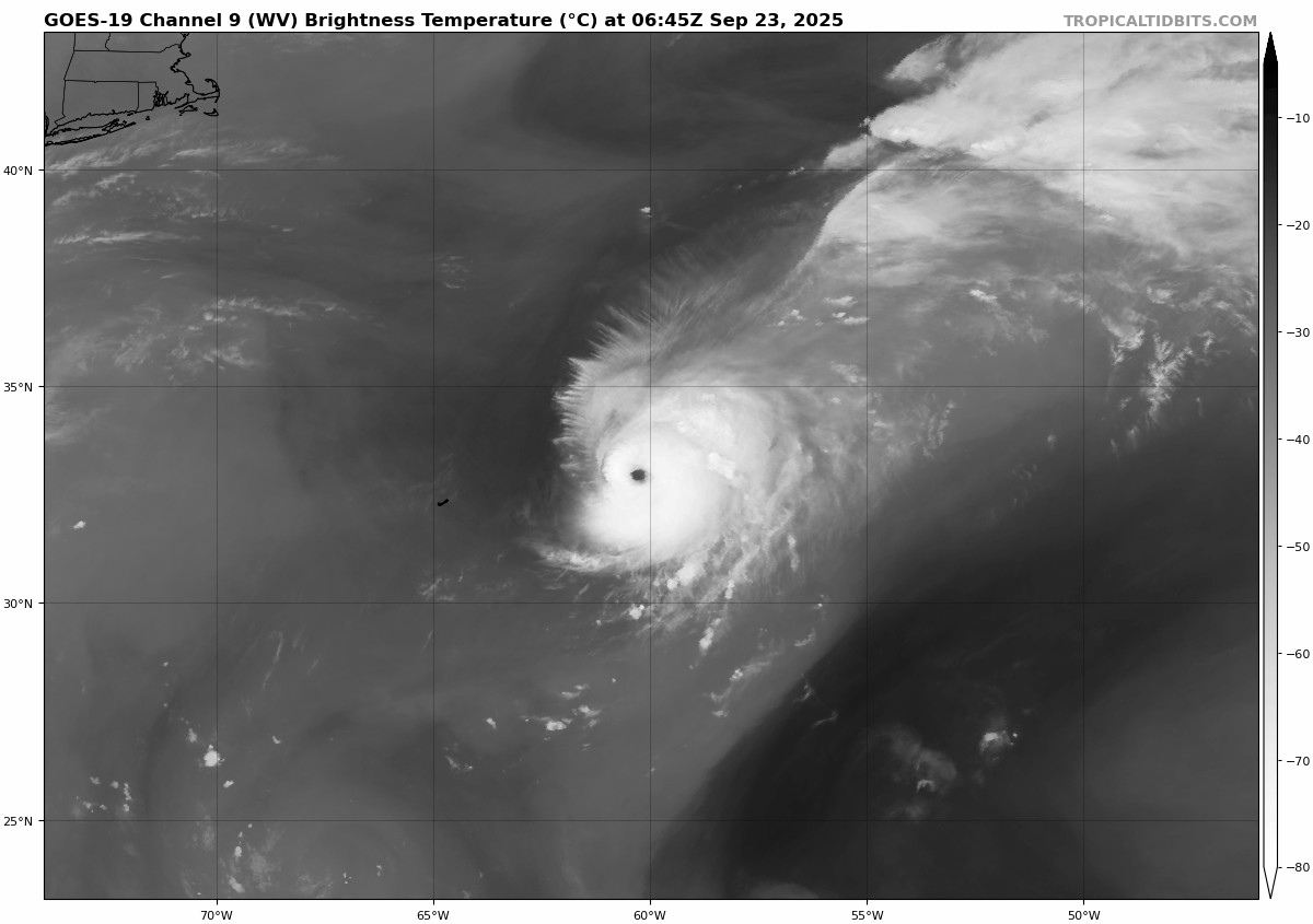
Figure 1: Water-vapor satellite imagery of Category 4 Hurricane Gabrielle moving northeast in the Atlantic Ocean. Note the spinning area to the south of Gabrielle (upper-level low) and the upper trough to the northeast, both enhancing storm outflow.
So what’s in store for Gabrielle and the communities in its path? The storm is expected to hold steady at major hurricane status for at least the next 24 hours. The latest forecasts from the National Hurricane Center call for a path very close to the Azores, potentially as a Category 1 hurricane or stronger. Figure 2 shows the forecast wind field from our in-house web app, KinetiCast.
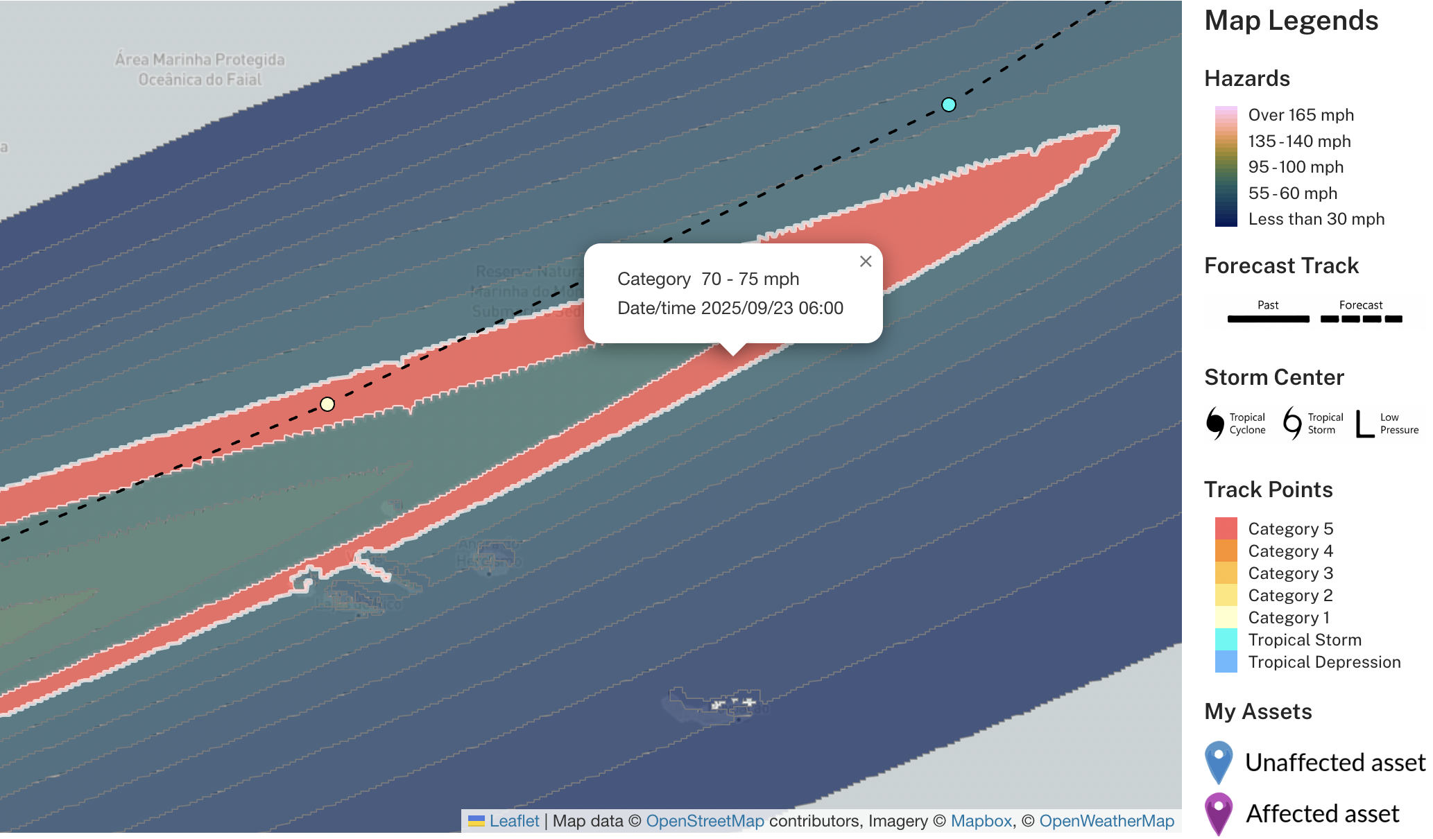
Figure 2: Zoomed-in view of Hurricane Gabrielle’s predicted wind field near the Azores. The highlighted red polygon shows an area with potential winds 70 – 75 mph.
Behind Gabrielle, two other areas are being monitored in the Atlantic Ocean, with medium/high chances of development per the National Hurricane Center (see Figure 3) [4]. The first is a tropical wave located near the Leeward Islands. This system has a 50% chance of development during the next 7 days [4]. Although model support for the development of this system is mixed, if it does develop, it is likely to have some form of impact on the Bahamas and the United States. However, it is still too early to speculate when and who might see impacts. The system further to the east is currently located over the tropical Atlantic and has a high (80%) chance of development in the next 7 days. This one is more likely to pass to the north of the Lesser Antilles, though it may still bring impacts to the islands or other communities such as Bermuda down the road. Again, it is simply too early to get into specifics, but the Atlantic will likely crank out at least another 1-2 named storms before the month of September ends.
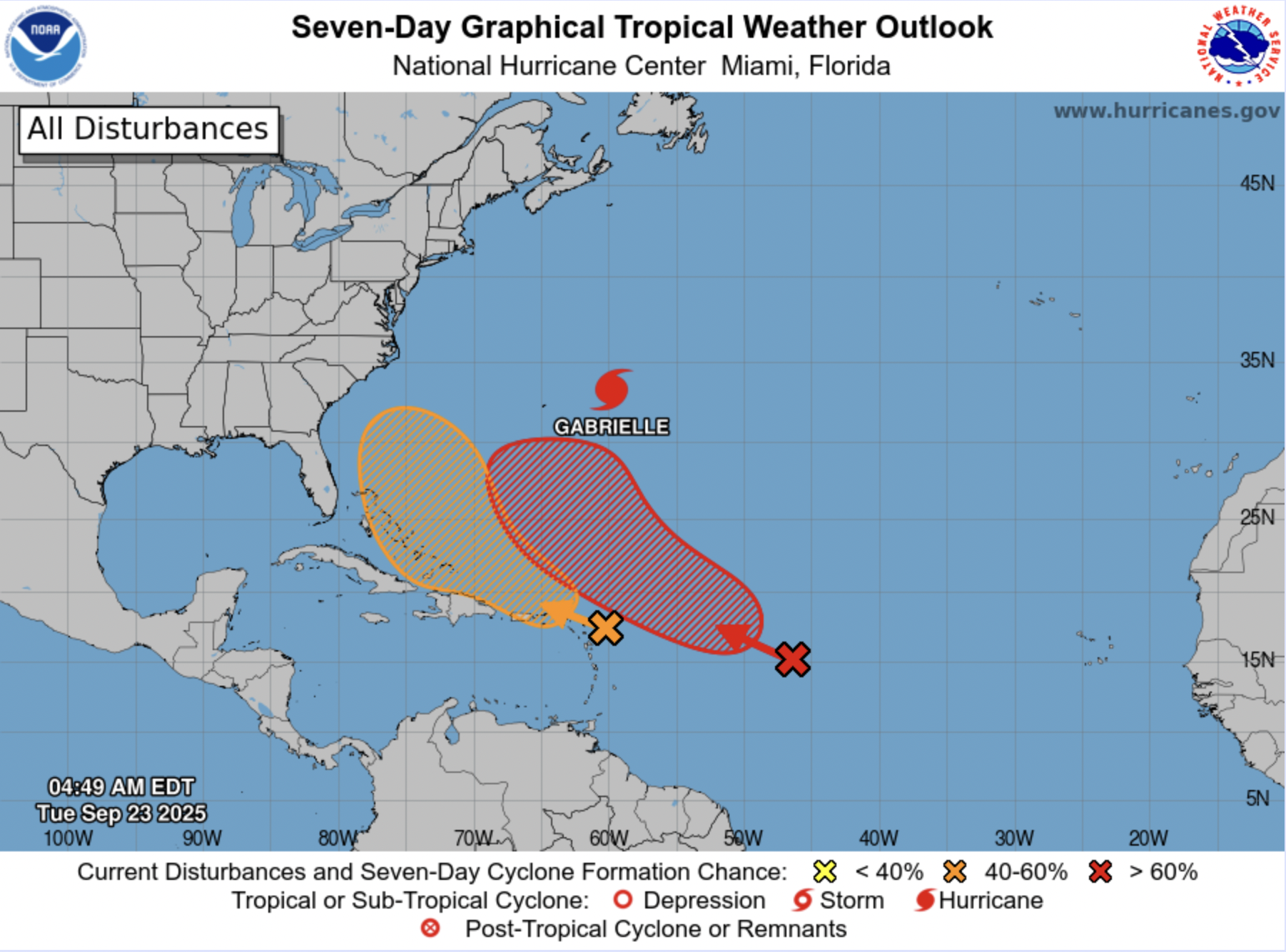
Figure 3: Forecast graphic from the National Hurricane Center showing Hurricane Gabrielle, as well as two areas of potential tropical development in orange and red.
But the Atlantic is not the only place where with action in the tropics. Typhoon Ragasa has been putting on a show in the Western Pacific the last few days. The system peaked as a Category 5 Super Typhoon and passed right over Calayan Island in the Philippines, bringing winds as high as 150 miles per hour and devastating impacts. Figure 4 shows the latest forecast from the Joint Typhoon Warning Center after using Kinetic Analysis Corporation models and topography to produce a simulated wind field down to <2 km resolution.
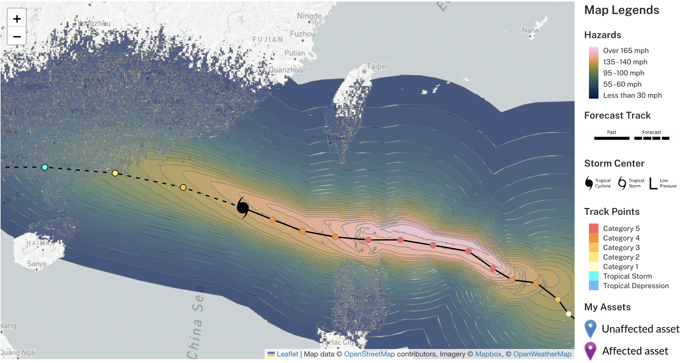
Figure 4: Typhoon Ragasa wind field from KinetiCast.
Ragasa is expected to continue moving west-northwest before making landfall in southern China. While the system has weakened from its peak intensity as a Category 5, it will still bring significant impacts. The biggest impacts are expected in China and Hong Kong, with estimated economic impacts of 15 billion and 11 billion USD, respectively (economic impact estimates are based on Kinetic Analysis Models loss calculations using wind and storm surge hazards, exposure and vulnerability data).
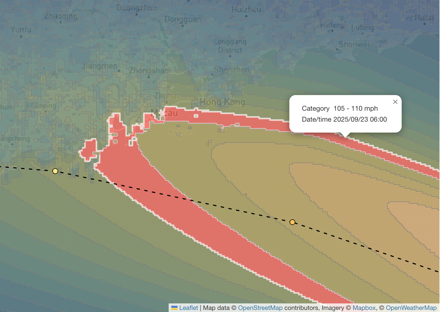
Figure 5: Zoomed-in view of Typhoon Ragasa’s simulated wind field near its predicted landfall point. The highlighted red polygon shows an area with potential winds of 105 – 110 mph.

Figure 6: Zoomed-in view of Typhoon Ragasa’s simulated storm surge potential near its predicted landfall point. The highlighted red polygon shows an area with potential surge of 6 to 9 feet.
As we near the end of the month, there is a lot of activity to monitor, with different communities around the world feeling the effects. However, hurricane season goes until the end of November, and we have seen significant hurricanes even after the climatologically busiest month of September (take Hurricane Milton just last year, which made landfall in Florida on October 9) [5]. Now is the time to be prepared and not let your guard down.
Have questions or concerns about how you can keep your property safe in hurricane-prone areas? Schedule a free consultation with us. Please email sales@kinanco.com.
References
1. https://edition.cnn.com/2025/09/21/weather/hurricane-gabrielle
2. https://www.nhc.noaa.gov/aboutgloss.shtml
3. https://www.tropicaltidbits.com/sat/
5. https://www.weather.gov/mlb/HurricaneMilton_Impacts