
Flash Floods Hit Texas Over the 4th of July Weekend, Second Deadliest in State’s History
Early Friday morning over the 4th of July weekend, residents in central Texas near Austin saw their homes inundated by rapidly rising floodwaters [1, 2, 3]. As the remnants of Tropical Storm Barry (which made landfall hundreds of miles to the south in Mexico) merged with a stalled frontal boundary, loads of atmospheric moisture were unleashed onto the state [1]. The effects were so rapid and dramatic, that the Guadalupe River near Hunt and Kerrville surged by over 26 feet in a matter of about 1 hour [2, 4] (Figure 1). This led to widespread inundation which, so far, has led to over 100 deaths, with many more missing [1]. This makes it the second deadliest flash floods in the state’s history. Tragically, 27 of the deaths reported have been from Camp Mystic, with the youngest victims being five campers aged 8-9 who died during the floods [2].
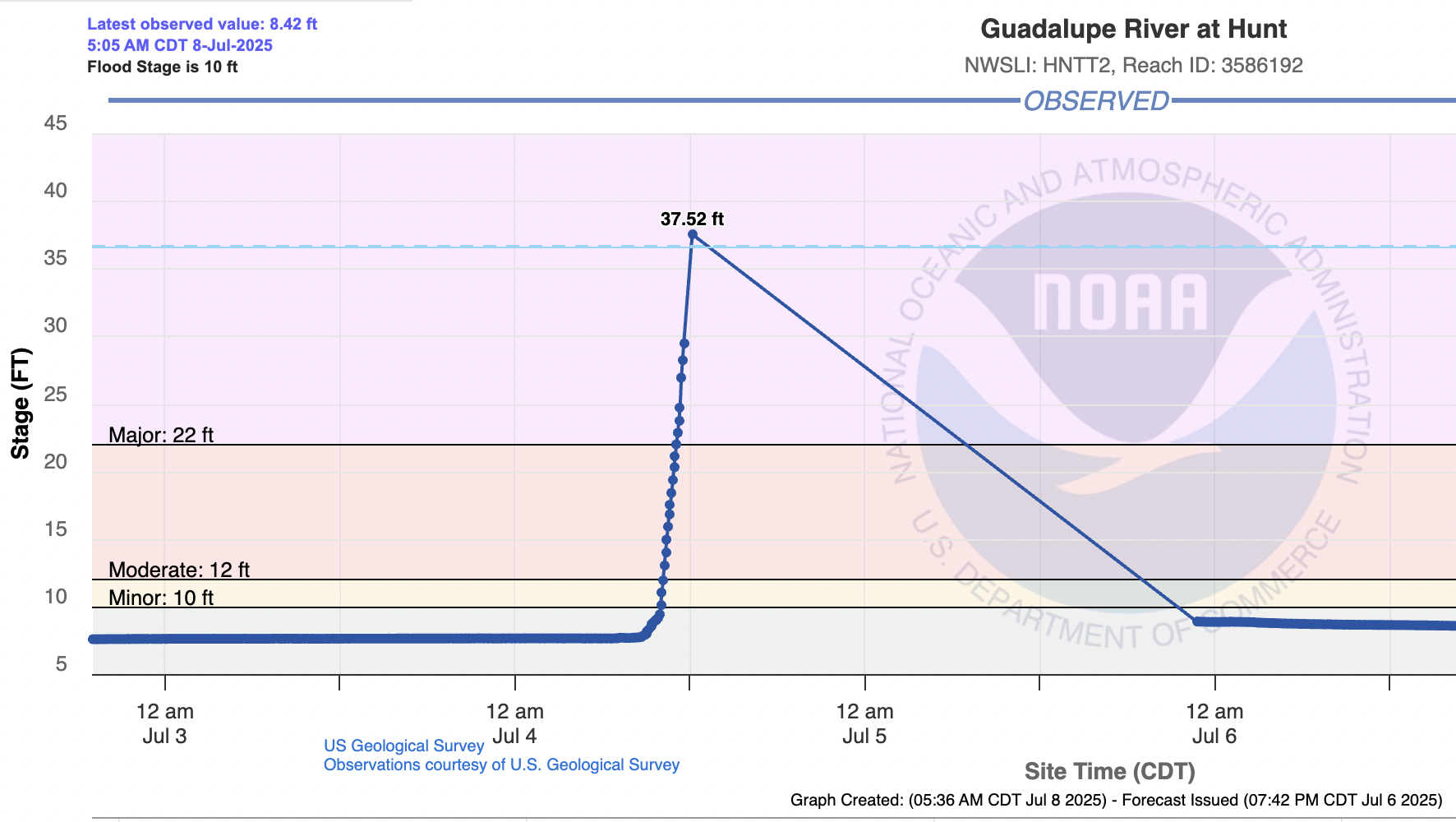
Figure 1: Guadalupe River flood report from U.S. Geological Survey. Source: https://water.noaa.gov/gauges/hntt2
But what caused the rivers to rise so rapidly in such a short time? And does the blame lie with agencies that are meant to provide the alerts and warnings meant to prevent this kind of loss of life?
Firstly, we will dive into the meteorological and geographic factors that led to the severe flooding, before addressing whether existing warning systems were sufficient. The first and most obvious cause of the flooding was the extreme rainfall that fell in a short time [4]. Rainfall totals reached over 20 inches in spots over a 7-day period, with most of this rain falling in the span of just a couple of days (Figure 2) [4]. Extraordinary rates of 2 to 4 inches per hour were also observed in some spots [4]. Weak steering currents enabled thunderstorms to remain nearly stationary and linger over the same spots for hours, exacerbating the amount of rain that fell onto a location. However, this part of Texas is also especially prone to flash flooding, with many referring to the region as “Flash Flood Alley” [4]. The region is marked by steep terrain, shallow soils, and repeated high rainfall events. The Guadalupe River Basin is one of the three most dangerous regions in the United States for flash floods, according to the Guadalupe-Blanco River Authority.
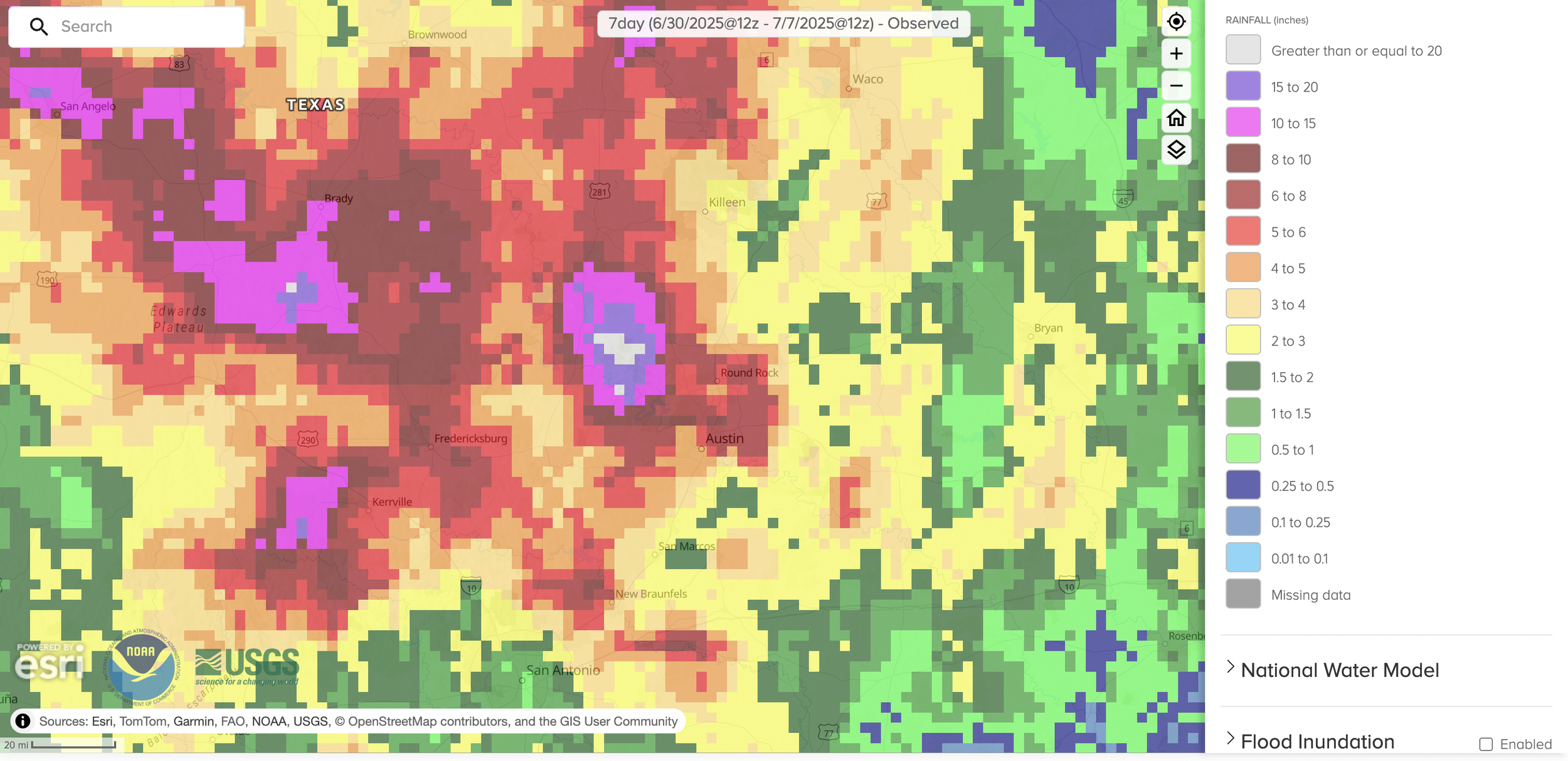
Figure 2: Cumulative rainfall map for central Texas near Austin for the last 7 days. Rainfall amounts greater than or equal to 20 inches are shown in white. Source: https://www.weather.gov/crp/texas_regional_rainfall
The Gulf of Mexico also provides an extensive source of moisture for the region, making high rainfall intensities a common occurrence. In addition, places like Hunt and Kerr Counties are situated on a floodplain between tall, rugged hills that funnel any rainfall down into rivers and creeks below [4]. In this event, the extreme rainfall funneled into the Guadalupe River, which led to the rapid rise in water levels [4]. The region's rocky topography makes it especially prone to flash flooding, according to the Texas Water Resources Institute. The type of clay-rich soil in the region contributes to the flash flooding because clay soils have low infiltration and trigger high water runoff once wet [4]. Furthermore, severe to exceptional long-term drought conditions were prevalent across much of south-central Texas when the downpours came [4, 5]. Drought conditions can often make an area more vulnerable to flash flooding because drought-stricken soil cannot absorb rainfall as efficiently, therefore making it more susceptible to runoff, like water would on a paved surface.
With all of this in mind, let’s look at the timeline for when the National Weather Service (NWS) issued its alerts. A Flash Flood Watch was issued on Thursday at 1:18 PM Central Time for Kerrville and surrounding areas; however, this was not an emergency alert [3]. The first flash flood warnings were issued around 11:41 PM local time later that night. By 1:14 AM, Friday morning, these were upgraded to Flash Flood Warnings (Considerable/Catastrophic), a rare and severe tag indicating an exceptionally dangerous situation [3]. Around 3:40 AM, NWS issued a Flash Flood Emergency for Kerr County, with urgent wording like “SEEK HIGHER GROUND NOW” [3]. So, the weather service was present and vigilant in issuing watches/warnings not only before the event, but also as the situation was unfolding. So, what went wrong?
Despite the alerts, the peak of the flash floods hit at a very unfortunate time. The most rapid rises in rivers happened between 2 and 5 AM, when most people were asleep or not monitoring weather updates [3, 4]. Also, the sheer speed of the river rises simply overwhelmed the capacity for human response. As mentioned previously, the Guadalupe River rose 26-29 feet in less than an hour in places, leaving little or no time to escape even with alerts [1, 2, 4]. The floods also impacted mainly rural areas, where many affected were in riverside campgrounds or RV parks, where access roads were quickly submerged or cut off and cell signals and outdoor alert systems were spotty [2]. However, perhaps most importantly is that the total rainfall and magnitude of the event simply exceeded initial forecasts and what many residents were anticipating – even seasoned locals [3, 4].
The flash floods remind us that effective and rapid warning systems are more crucial than ever in reducing loss of life from weather hazards. Hazards related to water – such as from storm surge and flash flooding – remain unfortunately one of the most common ways that people die each year from the weather. It is important that we continue to invest in better forecasts and warning systems, not cut already-strained forecast offices and agencies.
References
https://www.cbsnews.com/texas/news/central-texas-july-4-floods-one-of-deadliest-in-texas-history/
https://apnews.com/article/texas-flash-flood-severe-weather-camp-mystic-ef8e596833b145fef61451db92f32609
https://www.cbsnews.com/news/texas-flood-emergency-alerts-timeline/
https://abcnews.go.com/US/factors-contributed-extreme-texas-flooding/story?id=123531903
https://droughtmonitor.unl.edu/
https://mesonet.agron.iastate.edu/one/?lon=-99.0781&lat=31.0764&zoom=8×tamp=202507040700 (blog cover photo)