
Melissa Continues to Meander, Major Threat to Caribbean
Tropical Storm Melissa continues to crawl in the central Caribbean, with the center located south of Jamaica and Haiti. The system is expected to undergo some impressive intensification in the next few days, but this will depend largely on whether Melissa interacts with land early on or not. We will talk more about these specific details later in this blog post. For now, let’s look at the latest information as displayed in our interactive web app for tropical cyclones, KinetiCast™ (see Figures 1, 2).

Figure 1: Projected wind swath of Tropical Storm Melissa, generated by KinetiCast™ models using forecast data from the National Hurricane Center. The tropical cyclone symbol denotes the storm position for this forecast. The filled circles are color-coded by intensity. The circles on the dashed line represent the forecast position of the cyclone at 12-hour intervals, and the circles on the solid line depict the past position of the storm at 6-hour intervals.
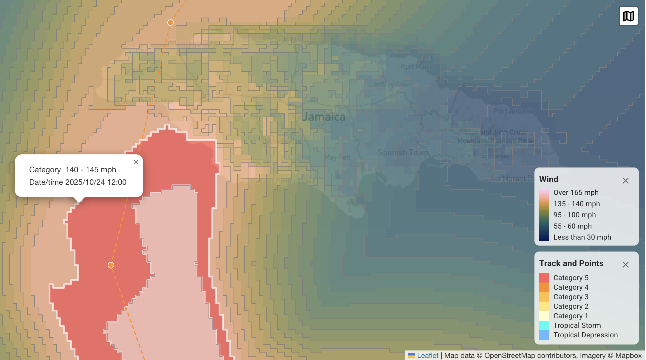
Figure 2: Zoomed-in view of the forecasted wind field (KinetiCast™) from what would be Hurricane Melissa near Jamaica. The highlighted red area shows where winds of 140-145 miles per hour have the potential to occur.
Over the next few days, the National Hurricane Center forecast expects intensification of Melissa into a 150 mile per hour, Category 4 hurricane. It is even possible that the system may reach Category 5 strength, a real possibility depicted from some of the models. If Melissa were to strike Jamaica directly at this intensity, it would be the strongest hurricane to do so since Hurricane Gilbert in 1988 [1]. There is some sensitivity in the exact future strength, though, as it will all depend on if Melissa interacts with Jamaica or other land areas before getting too strong. Most models have come into agreement in calling for a track to the south of Jamaica before an eventual bend north and northeast (see Figure 3); however, this is still 3-5 days out and could change.
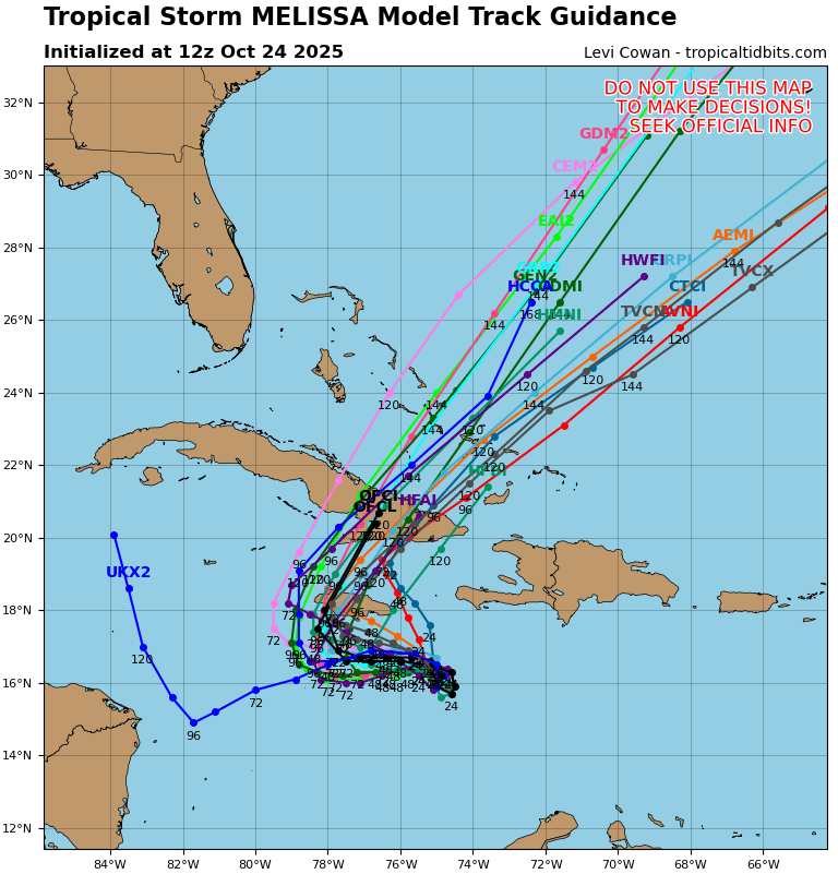
Figure 3: Tropical Storm Melissa Hurricane and Global Model Track Guidance, borrowed from tropicaltidbits.com.
While the exact track of the center matters for who sees the strongest winds, wind is far from the only hazard imposed by this storm. A much more concerning aspect is how the slow forward motion over the next several days will compound to produce potentially historic rainfall amounts. It has already been raining in parts of the Caribbean, such as Haiti and the Dominican Republic, and the mountainous terrain of many of these areas makes the threat from flooding and mudslides especially high. With Melissa expected to continue to meander for several more days before eventually turning north, most rainfall forecasts call for accumulations in FEET, especially for Jamaica (see Figure 4). This could be a setup for a truly historic rainfall/flooding event, and we hope that everyone in Jamaica and other parts of the Caribbean stay safe during this storm and heed advice from their local officials.
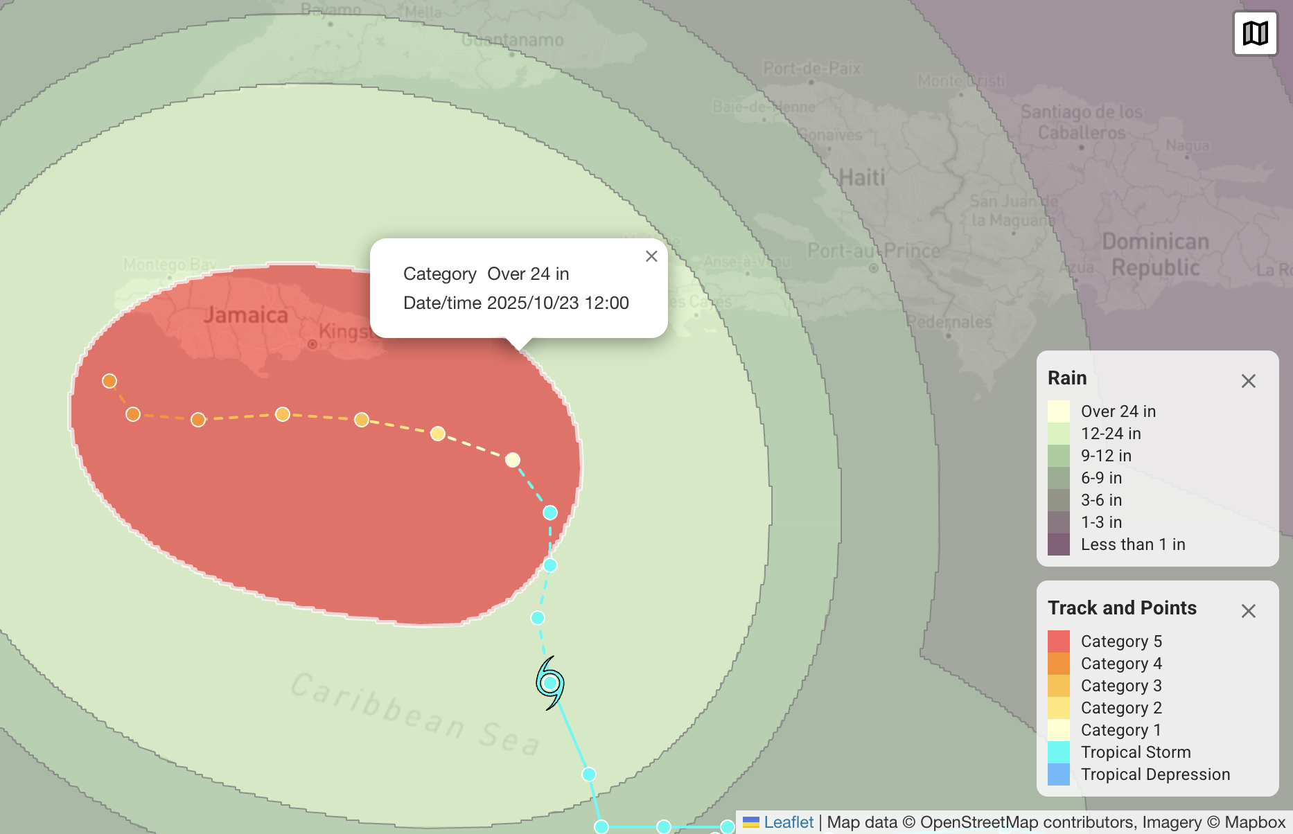
Figure 4: KinetiCast™ predicted cumulative rainfall from Melissa. The area highlighted in red shows the potential for over 24 inches of rain to fall over the next 5 days (this does not include what has already fallen).
After passing Jamaica, Melissa will likely affect Cuba and the Bahamas next. At this point it will be accelerating, though, so the main threat will be the high winds and storm surge. Melissa is not expected to significantly impact the United States, as a series of troughs and cold fronts should direct any system in this setup to the northeast and away from the U.S. [2].
We will continue to provide updates for Melissa over the weekend and into next week as the system closes in on parts of the Caribbean. Those in Jamaica, Haiti, Cuba, and the Bahamas should be putting their hurricane plans into place, stocking up on plenty of supplies and materials, and paying attention to the advice from local weather and emergency management officials.
References
https://www.weather.gov/lch/1988Gilbert
https://www.nhc.noaa.gov/mobile/refresh/MIATCDAT3+html/230838.html