
Typhoon Saola to Bring Serious Impacts to China, Macao, and Hong Kong
Last week, Typhoon Saola battered the northern Philippines after making a looping track very close to the nation (see Figure 1). The storm dumped torrential rainfall amounts, displacing thousands of people residing in low-lying villages and forcing them to seek shelter in government evacuation centers [1]. This comes just after last month, when Typhoon Doksuri lashed the northern Philippines with flooding rains [1]. Though the Philippines managed to avoid a direct hit from Saola, the storm has its sights set on some of the most populated and economically dense nations of the western Pacific: China, including the Chinese special administrative regions (SAR) of Hong Kong and Macao [1, 2].

Figure 1: Projected wind swath of Typhoon Saola, generated by KinetiCast™ models using forecast data from the Joint Typhoon Warning Center. The closed tropical cyclone symbol denotes the storm position for this forecast. The filled circles are color-coded by intensity. The circles on the dashed line represent the forecast position of the cyclone at 12-hour intervals, and the circles on the solid line depict the past position of the storm at 6-hour intervals. Note the looping track near the Philippines.
Figure 2 provides a zoomed-in view of the predicted wind field from Typhoon Saola over southern China. As the graphic shows, parts of southern China and Hong Kong may see winds of over 100 miles per hour from Typhoon Saola. This type of wind has the potential to cause significant structural damage, especially in the densely populated and urbanized areas near the projected path of the storm [1, 2]. What’s more is the storm could cause some notable coastal flooding as the onshore push of the wind funnels water into low-lying communities. The current storm surge forecast on KinetiCast™ shows a widespread area of 1 to 3 feet, with some of the more vulnerable coastal areas potentially seeing 3 to 6 feet of inundation (Figure 3).

Figure 2: Projected wind swath of Typhoon Saola from Figure 1, zoomed in to show the potential impact to China and Hong Kong.
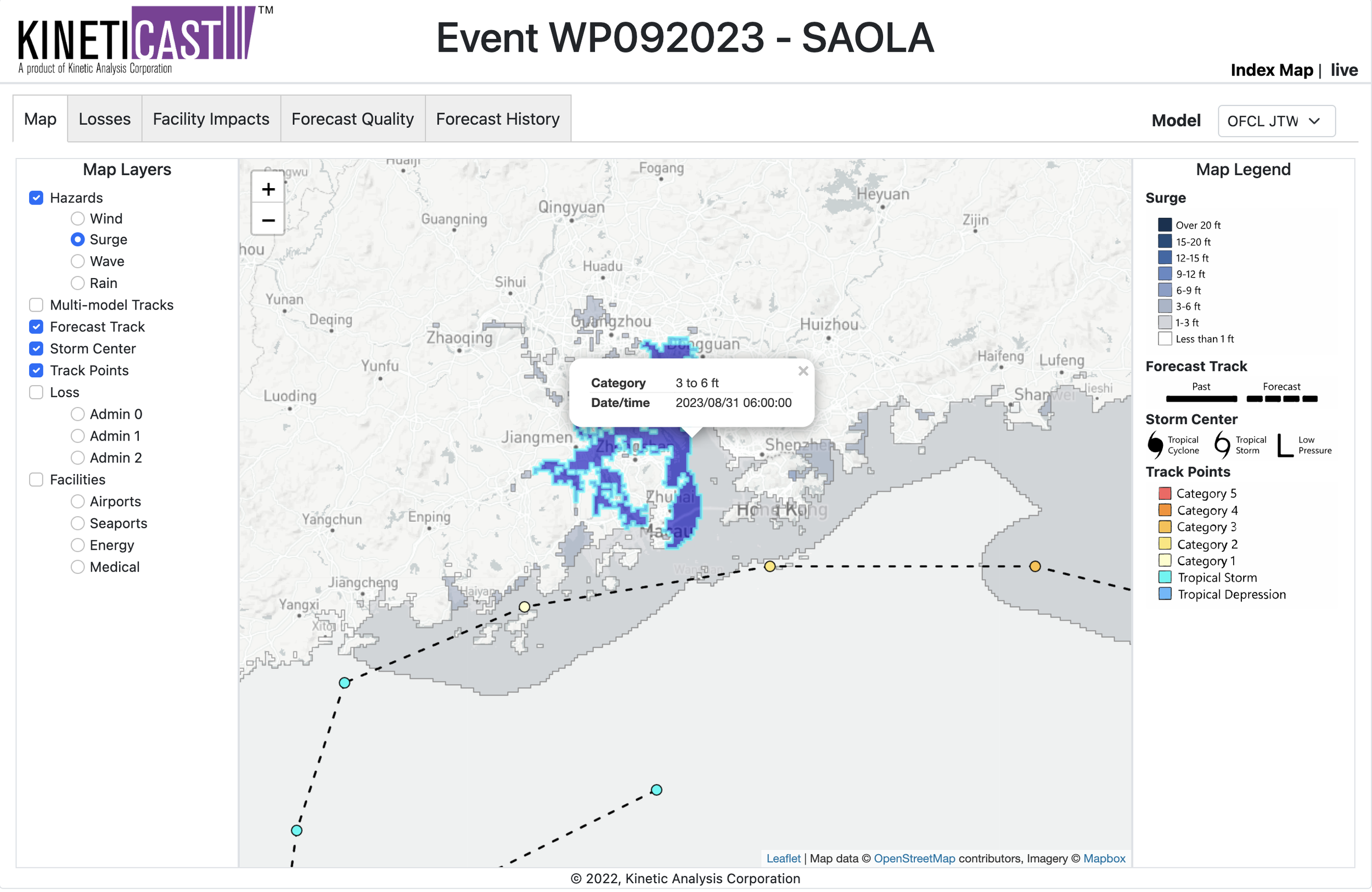
Figure 3: Forecast storm surge for Typhoon Saola , generated by KinetiCast™ models using forecast data from the Joint Typhoon Warning Center. The surge calculation includes the cumulative effects of pressure, wave setup, wind-driven water rise, and astronomical tides.
If you’ve read this far, perhaps you’ve taken note of the second looping track that Typhoon Saola is forecast to take (Figure 1). Saola is expected to slow down in the coming days before stalling in the South China Sea and making a turn back to the east. This forecast is several days out and could change over the next few days; nonetheless, it is important to note that if the storm stays that close to land, prolonged impacts due to wind and storm surge would be a great concern. In addition, some of the predicted rainfall totals from Saola are concerning. KinetiCast™ shows 12-24 inches of rainfall occurring over a large area of southern China (Figure 4), and these amounts could be higher in localized areas.
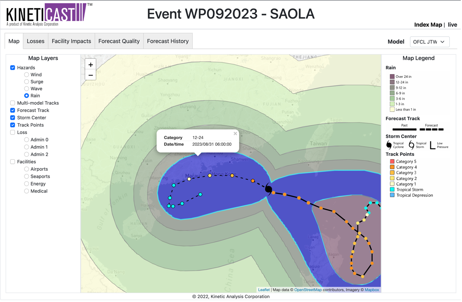
Figure 4: Forecast rainfall from Typhoon Saola, generated by KinetiCast™ models using forecast data from the Joint Typhoon Warning Center. The purple area is highlighted to show the potential for 12-24 inches of rain to fall over parts of southern China.
As we’ve alluded to already, the economic impact of the winds, rain, and. storm surge from Typhoon Saola could be significant. KinetiCast™ currently projects that winds and storm surge will cause over $4 billion USD in economic impacts in terms of Purchasing Power Parity (PPP) across all countries and regions affected (PPP is used to allow for quick comparisons between countries of different economic levels). Most of this is expected to occur in China (~2 billion USD in PPP), Macao (~1.5 billion USD in PPP), and Hong Kong (~441 million USD in PPP). As always, these projections are subject to change should the projected track or intensity of Typhoon Saola shift. Regardless, significant impacts are expected in southern China over the next few days from high winds, flooding rains, and storm surge.
After weeks of numerous tropical cyclones in the Atlantic basin, and with likely more to come, the western Pacific has roared back to life. Now is the time to ensure that you/your organization have an organized hurricane response plan in place. At Kinetic Analysis Corporation, our goal is to facilitate preparedness by providing you with accurate, near real-time information about a tropical cyclone as it unfolds. We do this by synthesizing data from a variety of sources and translating the meteorological hazards into easily understood impact information. This includes populations affected by tropical storm/hurricane force winds and storm surge, economic impacts and structural damage estimates, and shutdown times for facilities such as airports and seaports. All this information is available in our state-of-the-art web app, KinetiCast™. If you would like more information, please reach out to aagastra@kinanco.com.
References
1. https://apnews.com/article/typhoon-saola-philippines-taiwan-china-271a7133a34eba0f56f7582ddd8b7ef5
2. https://abcnews.go.com/Technology/wireStory/trains-suspended-people-warned-coastline-typhoon-saola-churns-102824246