
Updated October 30, 2026 | Focus: United States
El Niño is strengthening in the tropical Pacific, and forecasters expect it to influence weather across the United States during winter 2026–2027. Current outlooks favor warmer conditions across much of the northern U.S. and wetter weather across the South and East Coast. What that means for snowfall and individual winter storms, however, remains less certain.[1][2]
The latest on El Niño
NOAA’s Climate Prediction Center reported in early October that El Niño continued to strengthen, with ocean temperatures, winds, and tropical rainfall patterns all reflecting an established event. Forecasters put the probability of strong-to-very-strong El Niño conditions continuing through January–March 2027 above 83%.[1]
The International Research Institute for Climate and Society’s October 19 assessment reinforced that outlook. All 27 models in its ensemble predicted very strong El Niño conditions during December–February (see Figure 1). That agreement increases confidence that El Niño will remain an important winter influence, although it does not guarantee a particular outcome in any one region.[3]
This year’s exceptional El Niño event could top out with average sea surface temperature (SST) anomalies in the Niño 3.4 region between 3 and 4℃, which would be record-breaking. In fact, current SST anomalies in this region of the tropical Pacific are exceeding 4.5℃ in some spots (see Figure 2).
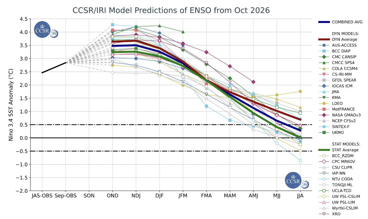
Figure 1: Predictions of mean ENSO conditions from various dynamical and statistical weather models. Source: https://iri.columbia.edu/our-expertise/climate/forecasts/enso/current/
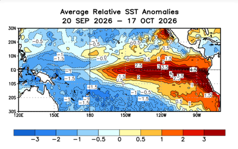
Figure 2: Average SST anomalies in the equatorial Pacific from September 20 to October 17, 2026. Source: https://www.cpc.ncep.noaa.gov/products/analysis_monitoring/lanina/enso_evolution-status-fcsts-web.pdf
Why a warmer Pacific matters
El Niño involves more than unusually warm ocean water. Changes in tropical Pacific temperatures affect rainfall and atmospheric circulation, which can influence the jet stream—the fast-moving current of winds in the upper troposphere that help guide weather systems.
During a typical El Niño winter, warm equatorial Pacific Ocean temperatures favor enhanced convection and rising motion, which strengthen the subtropical jet stream that extends across the southern United States. This favors a more active southern storm track, while northern areas often experience milder conditions and less storminess.[4]
It’s important to note that these patterns describe seasonal tendencies. They do not mean the jet stream will stay in one position or that every week will follow the same script.
In addition, the warmer Pacific Ocean temperatures during El Niño years result in elevated sea levels because of thermal expansion. During the strong El Niño of 1997-1998, wind-driven waves and abnormally high sea levels significantly contributed to hundreds of millions of dollars in flood and storm damage in the San Francisco Bay region. And this year, scientists are warning of a potential slow-moving Kelvin wave that is expected to hit southern California and contribute to a rise in sea level and coastal flooding throughout the region. [5, 6]
What could winter 2026–2027 bring?
NOAA’s winter outlook, released October 15, points toward several broad regional patterns for December 2026 through February 2027 (see Figures 3 and 4).[2]
A warmer northern United States. Above-average temperatures are favored across the Pacific Northwest, Midwest, and much of the northern country. NOAA also favors warmth across the Mississippi Valley and much of the East. This refers to the seasonal average; it does not rule out periods of freezing weather.[2]
A wetter southern tier and East Coast. Above-average precipitation is favored from the Southwest through the Southeast and along the East Coast. An active storm track could deliver repeated rounds of rain and, where temperatures allow, snow.[2]
Drier conditions in some northern regions. Parts of the northern Rockies and Great Lakes have increased chances of below-average precipitation. Some other areas have equal chances of above-, near-, or below-average precipitation.[2]
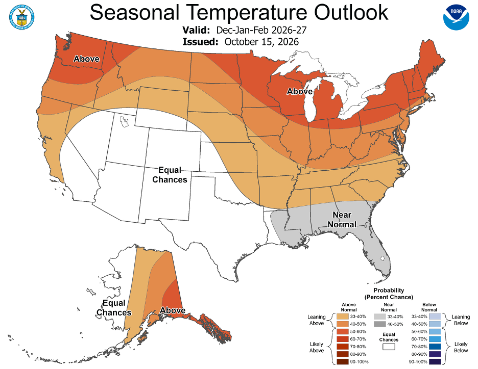
Figure 3: 2026-2027 U.S. Winter Temperature Outlook from the National Oceanic and Atmospheric Administration’s Climate Prediction Center. Source: https://www.noaa.gov/news-release/el-nino-looms-large-over-us-winter-outlook
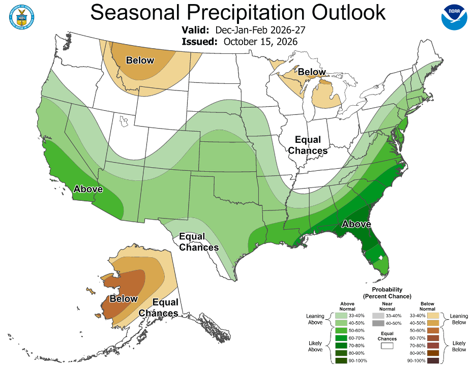
Figure 4: 2026-2027 U.S. Winter Precipitation Outlook from the National Oceanic and Atmospheric Administration’s Climate Prediction Center. Source: https://www.noaa.gov/news-release/el-nino-looms-large-over-us-winter-outlook
Will El Niño bring more snow?
A wetter forecast can sound promising to snow lovers, but precipitation and snowfall are different questions.
Snow requires moisture and cold air to coincide. A storm can bring abundant precipitation yet produce mostly rain if temperatures are too warm. NOAA’s historical analysis shows that El Niño’s relationship with snowfall varies across North America, with substantial differences among individual winters.[7]
For the Northeast and Mid-Atlantic, a wetter seasonal outlook alone cannot establish whether snowfall will finish above or below average. The timing of cold air and the paths of individual storms will matter.
NOAA explicitly states that its seasonal outlook does not predict snowfall accumulations. Temperature and precipitation outlooks provide useful context, but they cannot determine a city’s winter snow total months in advance.[2]
Could wetter weather help drought?
The southern precipitation outlook offers potential relief for drought-stricken areas. NOAA favors drought improvement or removal across the Southwest, Southern Great Plains, Southeast, and parts of the East Coast.[2]
However, the distribution of rainfall matters. Several moderate storms can have different consequences from a few intense downpours. NOAA also highlights the potential for heavy precipitation to cause flash flooding and mudslides.[2]
What remains uncertain?
Confidence in El Niño’s persistence is stronger than confidence in its local effects[RM1] . NOAA notes that a powerful event increases the likelihood of familiar El Niño impacts, but those impacts remain uncertain in any specific location. Influences from other large-scale teleconnections, such as the Pacific North American pattern and the North Atlantic Oscillation, are typically harder to predict in advance and further complicate the seasonal outlook.[1]
The most useful expectation for winter 2026–2027 is therefore a shift in probabilities: greater chances of northern warmth and wetter southern conditions, with snowfall and individual storm risks becoming clearer closer to each event.
As winter approaches, updated seasonal outlooks will refine the regional picture and forecasts will provide the detail needed for travel, outdoor plans, and storm preparation. Your local authorities, including the National Weather Service and emergency management officials, remain the most reliable source of information throughout the winter weather season.
References
NOAA Climate Prediction Center. “ENSO Diagnostic Discussion.” October 8, 2026. Read the discussion.
National Oceanic and Atmospheric Administration. “El Niño Looms Large Over U.S. Winter Outlook.” October 15, 2026. Read the winter outlook.
International Research Institute for Climate and Society, Columbia University. “October 2026 Quick Look” and accompanying technical ENSO update. October 19, 2026. Read the assessment.
NOAA Climate Prediction Center. “North American Winter Features.” Read about typical El Niño winter patterns.
5. U.S. Geological Survey. “El Niño Sea-Level Rise Wreaks Havoc in California's San Francisco Bay Region.” Read the discussion.
6. Scientific American. "The Kelvin Wave hitting California is a potent warning about sea-level rise.” Read about the impacts.
7. NOAA Climate.gov. “S(no)w Pain, S(no)w Gain: How Does El Niño Affect Snowfall Over North America?” Read the snowfall analysis.